On The Trail > Trips and Distances
Maps and information on this page can be studied in detail in our interactive Map Journal - (about the journal) (take me to it)
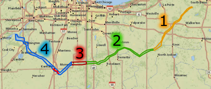
The Kankakee River offers a choice of paddling environments along its 133 miles. We've divided the river into four sections to reflect the distinctive characteristics of each:

1. Upper River - Kankakee Headwaters to the Yellow River: This entirely channelized section runs through farmland, with very little tree cover in many areas.
2. Wooded Channel - Yellow River to the State Line: This mostly channelized section has more tree cover and runs through several state parks and conservation areas.
3. Ancient Wetland - State Line to Momence: At the Illinois state line, the river reverts to a natural meandering course through some of the best wetland habitat in the Prairie State.
4. Grand Waterway - Momence to the Illinois River: A boater's and paddler's playground through urban and suburban areas, with a long run through Kankakee State Park before meeting the Illinois River.
Trips and Distance Charts - Allow at least 1 hour per 2 river miles travelled

Kankakee River - Indiana Trips |
|
|
Kankakee River - Illinois Trips |
|
1. Jasinski Landing > Kingsbury |
12.3 mi. / 19.8 km |
|
10. State Line Bridge > River Isle |
5.6 mi. / 9 km |
2. Kingsbury > Route 8 |
15.5 mi. / 25 km |
|
11. River Isle > Momence |
3.7 mi. / 6 km |
3. Route 8 > Yellow River |
5.4 mi. / 8.7 km |
|
12. Momence > Aroma Pk. |
11.7 mi. / 18.8 km |
4. Yellow River > Dunn’s Bridge |
8.6 mi. / 18.8 km |
|
13. Bird Park > Warner Bridge |
6.6 mi. / 10.6 km |
5. Dunn’s Bridge > Baum’s Bridge |
6.6 mi. / 10.6 km |
|
14. Warner Bridge > Area 9 Launch |
2.7 mi. / 4.3 km |
6. Baum’s Bridge > Grand Kankakee Marsh |
12 mi. / 19.3 km |
|
15. Area 9 Launch > Wilmington |
8.4 mi. / 13.5 km |
7. Gr. Kankakee Marsh > Shelby / Rt. 55 |
4.4 mi. / 7.1 km |
|
16. Wilmington > Des Plaines R. CA |
6.4 mi. / 10.3 km |
8. Shelby / Rt. 55 > White Oak Bayou |
6.8 mi. / 10.9 km |
|
|
|
9. White Oak Bayou > State Line Bridge |
3.6 mi. / 5.8 km |
|
|
|
|
|
|
|
|
Iroquois River - Indiana Trips |
|
|
Iroquois River - Illinois Trips |
|
A. Route 16 Access > State Line |
16.2 mi / 26.1 km |
|
B. State Line > Watseka |
22.1 mi / 35.5 km |
|
|
|
C. Watseka > Plato Bridge |
14.7 mi. / 23.7 km |
|
|
|
D. Plato Bridge > Aroma ParkĀ |
18.6 mi. / 29.9 km |
* * * * *
©2021 Northwest Indiana Paddlers Association

|